System for Ground penetrating radar (GPR) measurements
Description of equipment
Georadar is a non-invasive geophysical method that uses antennas of different frequencies to determine the presence of geological structures and other discontinuities in the shallow subsurface, and to track them continuously in space. The lightweight and mobile equipment allows fast and easy acquisition of field data, which is crucial in areas where other surveys are not possible due to access difficulties or the sheltered nature of the area. The GPR can thus provide information on the presence of fractures, fault zones, rock layering, karst caves and other openings, soil moisture and gases, as well as depth to groundwater, landslide slides, the thickness and properties of individual soil horizons and layers, and can also locate various buried objects and possible burrows, without disturbing the environment.
Due to its versatility, high efficiency and non-destructive nature, the use of GPR for subsurface exploration is rapidly expanding, but a wider range of antennas at different frequencies is needed to make the best use of the GPR method and make it more applicable. The higher the frequency of the antenna used, the lower the depth range and the better the resolution of the results. Antennas of higher frequencies (250 MHz, 500 MHz, 1.2 GHz) thus have a lower depth range and provide better resolution of results, and are therefore suitable for use in the search and investigation of phenomena of smaller dimensions shallower below the surface (search for pipes and cables, inspection of roads and concrete structures, determination of soil properties of agricultural areas, etc.). On the other hand, lower frequency antennas (30 MHz, 100 MHz) allow a deeper reach, which is particularly useful for investigating the geological characteristics of the subsurface. They can provide information on the presence and spatial orientation of various types of discontinuities which, among other things, influence the formation and stability of the surface, condition the hydrogeological dynamics of aquifers, limit the reserves of quarry material in quarries, and provide information on the spatial extent of individual stratigraphic members and subterranean karst phenomena.
The depth range and resolution of the results also depend to a large extent on the natural conditions - the properties of the material in which the electromagnetic waves travel and the amount of water and clay fraction present, which causes increased attenuation of the signal. Consequently, before starting a GPR survey, it is necessary to study the measurement area and select suitable antennas based on the desired depth range. The deepest range is provided by the 30 MHz RTA antenna, which is also the lowest frequency allowed for GPR measurements in Europe. Under good conditions, it can reach depths of up to 60 m, with a theoretical resolution of around 1.5 m. As the frequency increases to 100 MHz, the depth range decreases to around 20 m and the theoretical resolution to around 0.5 m. With a 250 MHz antenna, a depth range of up to about 8 m can be expected with a theoretical resolution of about 0.3 m, and with a 500 MHz antenna, a depth range of up to 4 m with a theoretical resolution of about 0.2 m. However, when using a High Frequency (HF) 1.2 GHz antenna, depths of up to 0.5 m with a theoretical resolution of a few centimetres can be expected, and are therefore also used in surveys of concrete structures to search for cracks and to analyse the condition of the reinforcement.
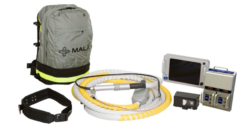
Technical data:
- ProEx system equipment
- ProEx control unit with optical module;
- powered by Li-Ion 12V battery;
- operating time 5 h, depending on configuration;
- operating temperature from -20° to +50°C;
- IP65 environmental;
- dimensions 32,5 x 22,2 x 4,2 cm;
- weight 1,9 kg.
- Antennas MALÅ
- 100MHz Antenna - Dimensions: 125 x 78 x 20 cm - Weight: 25.5 kg;
- 250MHz Antenna - Dimensions: 74 x 44 x 16 cm - Weight: 7.85 kg;
- 500MHz Antenna - Dimensions: 50 x 30 x 16 cm - Weight: 5.0 kg;
- 30MHz RTA antenna - Dimensions: length 13,06 m - Weight 7,8 kg;
- 1.2 GHz antenna - Dimensions 19 x 11.5 x 11 cm - Weight: 1.0 kg.
- High-frequency system
- Power supply: external 12 V DC battery, AC/DC voltage;
- Input 100-240 AC Output 13.2 V DC / 4.5 A;
- Running time 6 hours;
- charger: fast charger, automatic charging cycle;
- 100-240 V AC input;
- charging time 3-5 h (80-100%);
- Display: transactional 10.4" (CX11), weatherproof (IP 65);
- 410 x 210 x 55 mm + 40 mm convex details;
- weight 3,5 kg;
- Operating temperature - 20° C to + 50° C (- 4° F to + 122° F);
- Environmental IP 65;
- monitor with HF antenna accessories (CX12): CX12 Coldfire, 110/220V to 12V converter.
- Other
- Monitor XV - TFT LCD backlit display (640 x 480 pixels), transreflective;
- Rough Terrain Cart (RTC);
- distance measuring wheel (300mm or 150mm);
- Hip Chain distance meter with 2800m cotton cord.
- Software
- GroundVision 2 software for taking measurements;
- GPR-SLICE GPR Imaging Software for profile processing and final display of results.
Equipment rental
The use of the equipment is intended for GeoZS researchers. By agreement, we also carry out GPR surveys for external clients. The price is determined by the internal price list of GeoZS or by agreement.