Drone
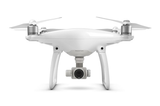
Description of equipment
Technical data:
- Camera: 20M pixels
- Maximum image resolution: 4096 × 2160 at 16:9
- Maximum video resolution: C4K:4096×2160 24/25/30p, 4K:3840×2160 24/25/30p
- Operating range: up to 3.5 km in the open, without obstacles
- Navigation system: GPS/GLONASS
- Flight time: 30 minutes
- Display: 14 cm (5.5 inch) high-brightness display, 1920×1080 resolution,
- 1000 cd/m2 brightness, Android OS, 4GB RAM+16GB ROM
- Visual obstacle avoidance system: vertically 0-10 m above the ground, horizontally at a distance of 0.7-30 m, at illuminance greater than 15 lux
- Automatic hover control: vertical +/- 0.1 m (in case of video positioning on) or +/- 0.5 m in case of GPS positioning, horizontal +/- 0.3 m (in case of video positioning on) or +/- 1.5 m in case of GPS positioning
- Maximum speed: 72 km/h (maximum climb speed 6 m/s, maximum descent speed 4 m/s)
- Control: the DJI GO app - details on the manufacturer's website
- Memory card: Micro SD, 16GB included, up to 128GB supported
- Charger: 100W
- Drone
- Operating temperature range: 0°C to 40°C
Access to equipment of equipment
Drone
Some possible uses:
- monitoring of changes (comparisons of the situation before and after storms, landslides, glacier dynamics, erosion monitoring, etc.),
- Terrain modelling (volcanic craters, glacial features, river banks, geomorphology, cliffs, beaches, outcrops, etc.),
- rivers and flood assessment (aerial flood damage assessment, river mapping and modelling, flood protection planning, river surveys, etc.),
- farmland management and analysis (irrigation systems, spray scheduling, vegetation analysis, identification of arid zones, etc.).
Equipment rental
The equipment is not for hire to external users.